The Bünting’s cloverleaf map, known as The World in a Cloverleaf and Three-petal map, of the German Protestant pastor, theologian, and cartographer Heinrich Bünting from 1581, Exhibition of the National Library of Israel calls „medieval Christian map of the Land of Israel” because it shows Jerusalem in the middle of the world surrounded by three continents.
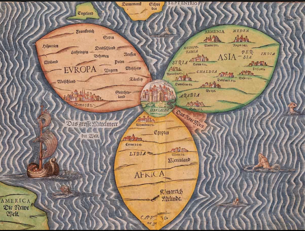
If “even proud Jerusalemites must occasionally admit that Jerusalem isn’t actually the center of the world, at least not in a geographical sense”, as the Exhibition page puts it, where could the center of the world be located?
According to the reconstruction, presented in the video presentation Jerash. The First False Jerusalem, Part One – also a video illustration of the book Phony Jerusalem – conducted by Russian scholars Anatoly T. Fomenko and Gleb V. Nosovsky, the old Tri-petal map shows Joros on the Bosporus Strait (today Istanbul, Turkey) located in the center where Europe, Asia and Africa meet. This is where the true evangelical Jerusalem was located.
For the Madaba Mosaic Map in the Church of Saint George in Madaba, Jordan,
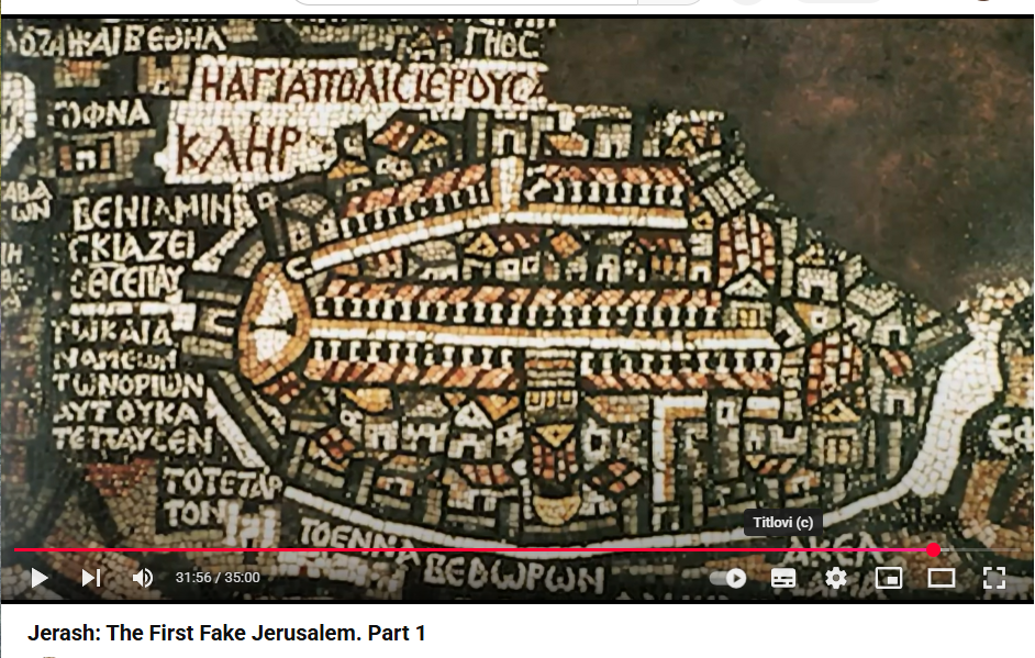
Fomenko says:
„The map was escavated in the late 19th century, and it is believed that the Mosaic was created during the time of Justinian I (527-565). What makes it remarkable? The center of the map features an image of Jerusalem. Furthermore, the name of the city is written in plain text on the map. There is a large enscription in the Mosaic, written in red. It reads, Hagia Polis Yerusa, with the end of the word being damaged. It is simply written, Hagia is holy, polis is city, and Yerusa is Jerusalem. … We thoroughly and meticulously photographed it in its entirety, along with all its fragments. In the center you can see a portion of the Mosaic that depicts Jerusalem in great detail, showing its layout, alleys, colonnades along the sides of the alleys, and the main temple which are depicted very intricately and are easily recognizable. I will immediately inform you of a very important conclusion we have made. It is asserted that this map perfectly corresponds to the map of Jerash in Jordan, which is the first false Jerusalem. Comparing this map with what you can see in Jerash today demonstrates that it is indeed the same place, the same city. It was the first pretended Jerusalem. And second assertion is that this Madaba map does nor correspond at all to today’s Jerusalem in Palestine. There is no resemblance whatsoever. The map of Jerusalem, both the modern one and the map of the old Jerusalem made in the 19th century, bears no resemblance to the Madaba map. Therefore, this remarkable map indeed contains evidence that Jerash is the first new Jerusalem created after the genuine Jerusalem. The Gospel Yeh Ross on the Asian coast of the Bosphorus was plunged into oblivition and left as a holy place only for initiated, while a new Jerusalem Jerash was made for people, for ordinary folks.”
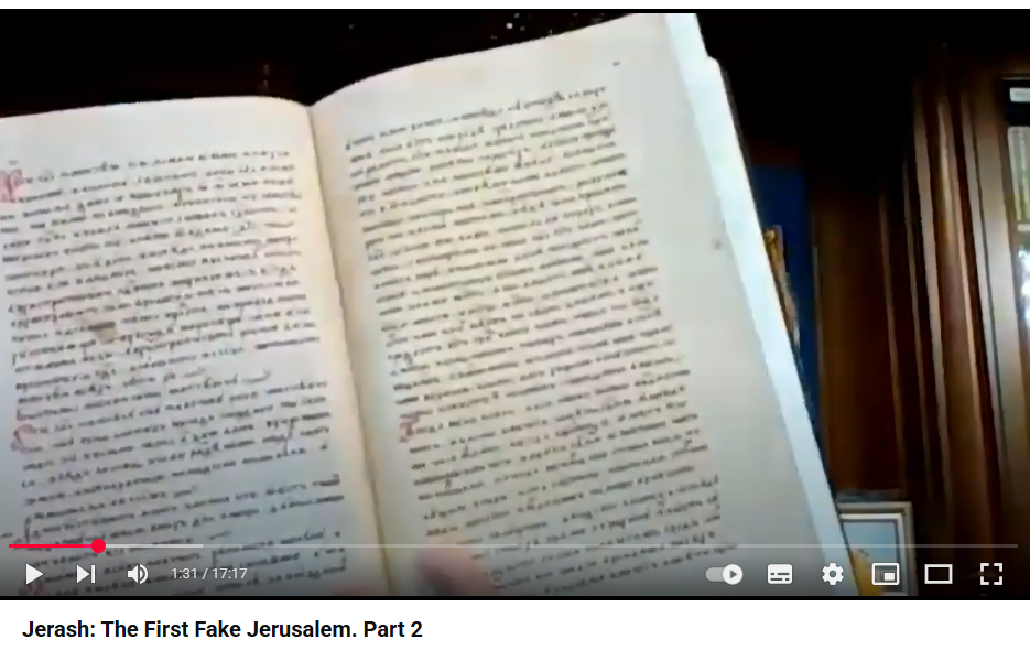
Video Jerash: The First Fake Jerusalem, Part 2 discusses in detail part of the content of a Russian chronicle from 1649, discovered a few years ago in a private library, and published by the Oktyon publishing house in 2019. Later, Fomenko and Nosovsky discovered that several copies of the Chronicle were in some closed storages that were being studied by historians, but it was obvious that they were not reporting on its contents.
“So in this chronicle, there is a section dedicated to the journey to Jerusalem during the reign of Ivan the Terrible.”, says Gleb V. Noskovskij, along with Anatoly Fomenko, co-founder of the New Chronology which modern science considers pseudohistory. “This journey is described in great detail. The Russian cities are mentioned through which the route from Moscow passed. … The author speaks of two possible routes. One route goes overland through Damascus, but they did not take that route. The second route went through Jaffa. Jaffa is modern city of Tel Aviv. It was called Jaffa back then, and the chronicle mentions the name Jaffa. The pilgrims arrived in Jaffa, disembarked, and then continued eastward toward Jerusalem as a caravan. …
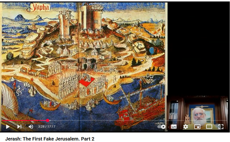
… First, they went to Rama, and then from Rama to Jerusalem. … This is a modern map, so it says Tel Aviv insted of Jaffa. Although it is written as Jaffa at the bottom..
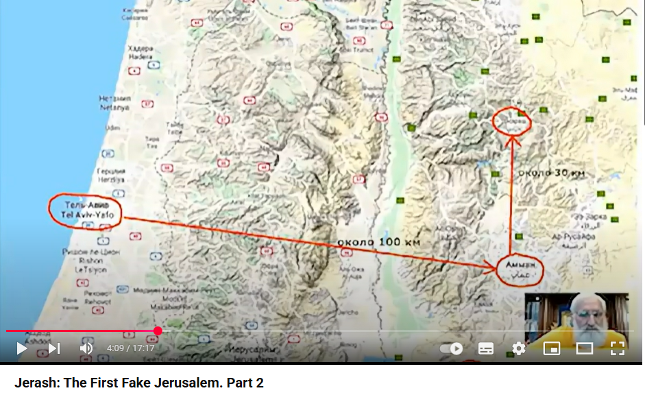
So, it was described how the pilgrims walked … to the east, to a certain town called Rama. Then … to Jerusalem, passing through rocky mountains, and it was specified how much time it took them to pass through these rocky mountains before arriving in Jerusalem. …
In reality, to the east of Tel Aviv, there is only one major city and Rama is described as a major city. If we do not consider various villages, this city is the only one, which is today known as Amman.
As we can see, it is written here [on the map] in Arabic with an ēn. The first letter is an Arabic en, which sometimes, when translated into Russian becomes r. Therefore, this Arabic name can be translated into Russian as either Amman or Raman.
I want to tell you what we saw there. I will show you various maps. This is the route from Rama/Amman to Jerash/Jerusalem. It indeed passes through rocky mountains. Here on the map it is shown in more detail how to go from Rama to Jerusalem. Everything is measured in both steps and hours, and it precisely matches what the chronicle describes.
Let’s take a close look at this map..
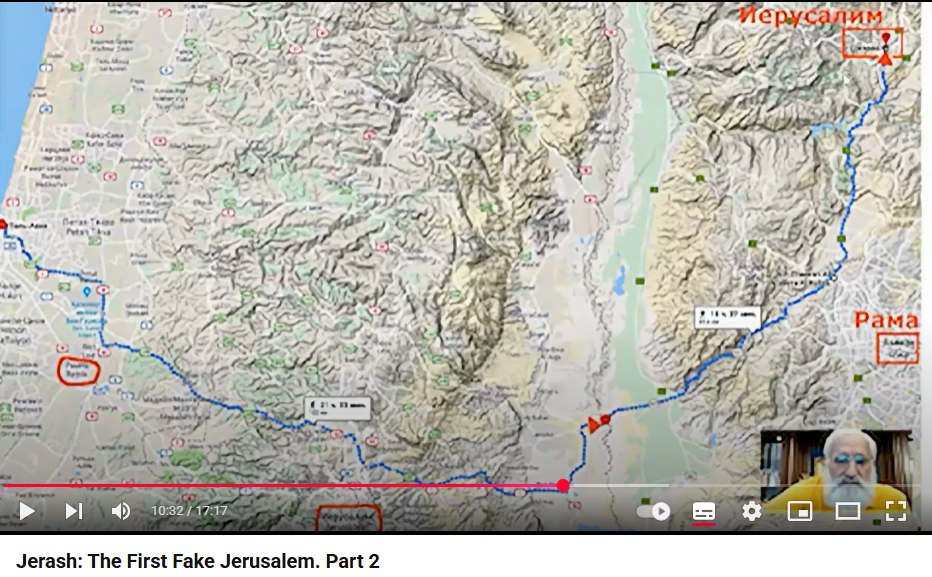
It shows what the pilgrim actually described and what European explorers found when they ventured into these areas in the 19th century. Trying to find Jerusalem based on similar descriptions. They also read that the pilgrims disembarked in Jaffa and then continued eastward. And in fact, those who were searching for Jerusalem had to travel the same way. They had to first reach Rama, which is also Amman, and then proceed northeast to Jerash. What did they do? In the 19th century when they were searching for it Jerash was covered by a mudflow and buried under a 4-meter layer of soil.
There wasn’t much sticking out there and they did not find it. So they stopped to early. They covered only about one-third of the distance and turned in that direction. They found some mountains, passed through them, and found the village of Al-Quds. They believed it was the best match for the descriptions. Of course, they did not find any Rama, and they later named some Arab village Rama. They interpreted the name Al-Quds as holy in Arabic. They renamed it to Jerusalem and said, well, it fits. Jerusalem is a holy city. Al-Quds means holy, so this must be Jerusalem. They also allegedly found here the other names mentioned in the sources. In other words, they simply renamed Arab villages to match the required names, and traces of their search efforts are visible. They ended up with two Ramas. One is called Ramla, and there is another one here. So, they indeed searched and tried to map everything. They just didn’t go far enough. They had to go approximately two to three times further..
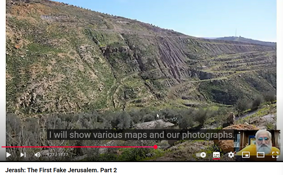
In the 20th century Jerash was excavated. It is still not fully excavated. And here is a panorama from one of the high points. …
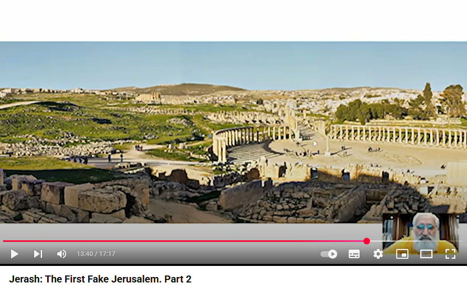
From the very beginning this Jerusalem was for show. More precisely, it was an ancient roman sanctuary ...